DESCRIPTION
ps.output is a cartographic mapping program for producing high quality
hardcopy maps in PostScript-3 format. Output can include a combination of two raster maps, any
number of vector overlays, notes, decorations, and other spatial data.
A file of mapping instructions that describes the various spatial and textual
information to be printed must be prepared prior to running ps.out.
Then, the better use is writing a script file as:
ps.out [flags] output=FILE << EOF
(ps.out commands)
EOF
The hash character ('#') may be used at the beginning of a line
to indicate that the line is a comment. Blank lines will also be ignored.
NOTES
The order of commands is generally unimportant but may affect how some layers
are drawn. ps.out first draw the masked areas, lines, points, and labels,
second the unmasked areas and lines, and finally the grids, unmasked points and unmasked labels.
Raster maps are always drawn first, and only a raster map command may be used.
Be aware that some mapping instructions require the end command
and some do not. Any instruction that allows subcommands will require
it.
The resolution and extent of raster maps plotted with ps.out are
controlled by the current region settings via the g.region module. The output filesize is largely a
function of the region resolution, so special care should be taken if
working with large raster datasets.
For example if the desired output is Letter sized paper at 300dpi, with 1"
margins and the raster filling the entire page, the usable area on the page
will be 6.5" x 9", which at 300 dots/inch is equivalent to a region of 1950
columns x 2700 rows (see "g.region -p"). Any higher resolution
settings will make the output file larger, but with a consumer printer you
probably won't be able to resolve any better detail in the hardcopy.
The user can specify negative or greater than 100 percentage values for
positioning several map decorations and embedded EPS-files, to move them
outside the current map box region (for example to position a caption,
barscale, or legend above or below the map box).
One "pixel" is 1/72 of an inch or 127/360 (aprox. 0.35) of a millimetre.
For users wanting to use special characters (such as accented characters)
it is important to note that ps.out uses ISO-8859-1
encoding. This means that your instructions file will have to be encoded in
this encoding. If you normally work in a different encoding environment
(such as UTF-8), you have to transform your file to the
ISO-8859-1 encoding, for example by using the iconv
utility:
iconv -f UTF-8 -t ISO_8859-1 utf_file > iso_file
MAPPING INSTRUCTIONS
The mapping instructions allow the user to specify various spatial data to
be plotted. These instructions are normally prepared in a regular text file
using a system editor. Except scale, all instructions are multiple
line followed by a subsection of one or more additional instructions and
are terminated with an end instruction.
Instruction keywords:
draw
geogrid ERROR IN SOUTH HEMISPHERE?
grid
maparea
note
palette
paper
raster
rlegend
scale
scalebar
vareas
vlabel
vlines
vpoints
vlegend
Convention in description of some instructions:
- # number without dimension
- The number is considered in points.
- #- number with dimension
- Acceptable units are mm (millimeters), cm
(centimeters), inch (inches), and % (percent of map
dimensions).
- CAT List of categories e.g. 1,3,5-7
- SQL SQL where statement like: vlastnik = 'Cimrman'
- T Text
- R Raster file or group name if the first character is ':'
- V Vector file name if equal to '(none)' then don't draw but there is present in vlegend.
- color Color name
- The color may be either a standard GRASS
color, a R:G:B triplet (e.g '255:0:0'), or
none. In all cases could be follow by $alpha to set the
opacity (if use -g flag).
The following colors names are accepted by ps.out: aqua,
black, blue, brown, cyan, gray, grey, green, indigo, magenta, orange,
purple, red, violet, white, yellow.
- COOR Coordinates as pair of east north
- font command:
font
    name   [T]
    size   [#-]
    color  (color)
    extend [#]
end
-
The name of the PostScript font. Fonts present in all PostScript implementations are:
Times-Roman,
Times-Italic,
Times-Bold,
Times-BoldItalic,
Helvetica,
Helvetica-Oblique,
Helvetica-Bold,
Helvetica-BoldOblique,
Courier,
Courier-Oblique,
Courier-Bold,
and
Courier-BoldOblique
.
- frame command:
frame
    where  [#- #-]
    ref    [left|right|center upper|lower|center]
    offset [# #]
    border [#-]
    color  (color)
    fcolor (color)
    margin [#-]
end
- line command:
line
    width [#-]
    color (color)
    style [solid|dashed|dotted|dashdotted|#...]
    cap   [butt|round|extended_butt]
end
COMPOSE THE MAP
paper
Specifies paper size, margins and orientation.
USAGE
paper [paper type]: default A4
    height [#-]
    width  [#-]
    left   [#-]: default 0.5inch
    right  [#-]: default 0.5inch
    bottom [#-]: default 1.0inch
    top    [#-]: default 1.0inch
    landscape [y|N]: default N
    draw   (draw)
    font   (font): set the default font
end
- paper types: A0-6, B0-6, Executive, Folio, Ledger, Legal, Letter, Tabloid.
- left and top: They are referenced to upper-left
margin of the paper and they specify the position of the map area (i.e.
grids growth outside this limits).
- draw: This paints the features before any part of map. Usefull to draw logos, watermarks...
EXAMPLE
paper A4
    left 2cm
    top 4cm
    landscape y
    font
        name Univers
        size 8
    end
end
This example set the size of paper to landscape A4 and Univers 8 point as defualt font.
scale
Selects a scale for the output map.
USAGE
scale 1:[#]
The scale is selected as a relative ratio, e.g. 1:25000. Use maparea to select a specific width of map.
EXAMPLE
    scale 1:25000
This example would set the scale of the map to 1 unit = 25000 units.
maparea
Position of the map area on the page.
The upper left corner of the map will be positioned left units
from the left edge of the page and top units from the top of the
page. If width and height are present, the map will be
rescaled, if necessary, to fit.
USAGE
maparea
    left   [#-]
    top    [#-]
    width  [#-]
    height [#-]
    border [#-]
    color  [color]
    fcolor [color]
 end
- border and color: To control the which and color of the line is drawn around the map area.
- fcolor: Fill map-area with color (or none), e.g. aqua to sea color.
EXAMPLE
maparea
    left 2cm
    top 3.5cm
    border 1mm
    color black
    fcolor none
end
This example positions the upper left corner of the map 2.0 cm from the
left edge and 3.5 cm from the top edge of the map. And draw a black border
of 1 mm of width around the map area.
ADDING COMPONENTS
grid
Overlays a coordinate grid onto the output map.
USAGE
grid
    major  [#] (line)
    minor  [#] (line)
    cross  [#]
    font   [font]
    fcolor [color]
    format ['in', 'out', '+out' or 'iho']
    cutoff [#]
 end
EXAMPLE
grid
    format in
    major 1000
        width .1mm
        color gray
        style 12
    end
    minor 200
        width .05mm
        color gray
        style 12
    end
    font
        name Univers
        size 7
        color white
    end
    fcolor black
    cutoff 3
end
|
|
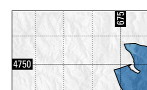
format: in |
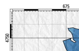
format: out |
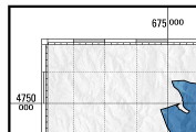
format: iho |
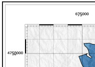
format: can |
This example would overlay a gray grid with a spacing of 10000 meters (for
a metered database, like UTM) onto the output map. Alternate grid lines
would be numbered with white numbers on black boxes.
geogrid
USAGE
geogrid
    major  [#] (line)
    minor  [#] (line)
    font   [font]
    fcolor [color]
    format ['in' or 'out' or '+out']
 end
EXAMPLE
geogrid
    format out
    major 30'
        width .3
        color magenta
    end
    minor 5'
        width .1
        color magenta
        style 1
    end
    font
        name Univers
        size 5
        color black
        extend 1.2
    end
    fcolor none
end
scalebar
USAGE
scalebar   [scalebar type]
    length [#]
    units  [code T]
    major  [# #], divisions and label separation
    minor  [# #], divisions and label separation
    frame  [frame]
    font   [font]
    height [#-]
    fcolor [color]
end
Scalebar types: I F f S s
EXAMPLE
scalebar f
    frame
        where 50% 0%
        offset 0 12
        ref center upper
        border 0.5mm
        color black
        fcolor gray
    end
    font
        name Univers
        size 8
        color black
    end
    length 20
    units km Kilometers
    major 5 2
    minor 2 2
    height 2mm
end
note
USAGE
note [code T]
    frame [frame]
    font [font]
    angle [#] in degrees
    width [#-]
 end
Note codes: :file (filename),
:maplim,
:dimen,
:scale (pre-text)
or simple text use '|' to break lines (max 1024 characters)
EXAMPLE
note :scale scale
    frame
        where 0% 0%
        offset -12 -4
        ref left lower
        border 0
        fcolor none
    end
    angle 90
    font
        name Univers
        size 6
        extend 1.25
        color gray
    end
end
palette
draw
USAGE
draw [free]
    direct (T)
    color (color)
    fcolor (fill color)
    linewidth line_width
    linedash line_width
    font name size [extend]

    [l,r,c,x,v,]text east north label or -1 angle label
    textc east north label
    labels filename

    moveto east north
    lineto east north
    endline

    line east1 north1 east2 north2
    rectangle east1 north1 east2 north2 [fillcolor]
    circle east north radius
    arc east1, noth1, diameter, east2, north2
    border width

    psfile scale east north filename

    maplimits
    north east north radius
    compass east north radius
    rute east north label
end
ADDING RASTER MAPS
raster
Selects a raster map for output.
USAGE
raster [R|R R R], required: one raster, one group name (:name) or three raster (R G B)
    grey      [y|N]. Output in shades of grey.
    maskcolor [color]. Color to be used for mask.
    maskcell  [R (R)]. Raster used as mask and optionally a raster for background.
    outline   [line]. Specifications of outline.
    setcolor  [CAT color]. Overrides the color of cat
end
EXAMPLE
raster geology
    grey n
    maskcolor none
    maskcell geo_mask elev_state_500m
    outline
        width .01
        color black
    end
    setcolor 28 200:123:200
end
ADDING VECTOR MAPS
vareas
Draw a vector of areas with optional pattern. Fill or pattern color can be fixed or reed from database.
A line vector could be drawn as an area when lwidth is not zero (positive or negative).
If label = "" not block title.
USAGE
vareas [V]
    lwidth [#-], default: 0 (area).

    line   (line)
    fcolor (color | RGBCOL$alpha [IDCOL])

    pat    [TXT]. Pattern EPS file.
    pscale [#]. Pattern scale.
    pwidth [#]. Pattern line width.

    island [Y|n]. Draw island as normal areas (fill as normal area then hide it).

    layer  [#], default: 1. Layer number used with cats/where option
    cats   [CAT]
    where  [SQL]
    masked [y|N]. Masked or not by raster mask
    label  [TXT]. For description or title in vlegend
    lpos   [# #]. Position where vector is plotted in legend and block

    setrule [ID.CAT[:ID] TXT]. Set a label for the CAT.
end
vlines
Perhaps offset dont run well in Lat/Lon
USAGE
vlines [V].
    type   [line|boundary], default: line

    line   (line)
    rgbcol [T]. Column name with line color data
    hline  (line)
    offset [#-]. hline offset, default: 0.

    layer  [#], default: 1. Layer number used with cats/where option
    cats   [CAT]
    where  [SQL]
    masked [y|N]. Masked by raster mask
    label  [T]. For description in vlegend
    lpos   [# #]. Position where vector is plotted in legend and block
end
EXAMPLE
vlines railroads
    type line
    label Rail roads
    line
        width .4mm
        color green
    end
    hline
        width .1mm
        color black
    end
    masked n
end
vpoints
Draw a vector of points with a symbol.
A line vector could be drawn as a lines ...
USAGE
vpoints [V].
    type   [point|centroid|line|boundary], default: point

    symbol [T]. Symbol standard or EPS file.
    line   (line)
    fcolor (color). Fillcolor
    size   [# | SIZECOL #]. Size or size column (and legend size).
    scale  [#- #-]. Scale and bias to rescale sizecol.
    rotate [# | ROTATECOL]. Rotate or rotate column.

    dist   [#-]. Distance between symbol on the cline
    offset [#-]. Vertical offset of the symbol
    cline (line). Conection line of the symbols

    layer  [#], default: 1. Layer number used with cats/where option
    cats   [CAT]
    where  [SQL]
    masked [y|N]. Masked by raster mask
    label  [T]. For description in vlegend
    lpos   [# #]. Position where vector is plotted in legend and block

    setrule [SIZE.CAT[:ID] TXT]. Set a label for the CAT.
end
EXAMPLE
vpoints precip_30ynormals
    type centroid
    symbol basic/circle
    fcolor red
    line
        width .2
        color black
    end
    size 10 ANNUAL
    scale .01
end
vlabels
USAGE
vlabels [V].
    labelcol [T]
    font  (font)
    decimals [#]
    circled [Y|n]

    layer  [#]
    cats   [CAT]
    where  [SQL]
    masked [y|N]
    label  [T]
    lpos   [#]
end
EXAMPLE
vlabels railroads
    labelcol cat
    masked n
end
ADDING LEGENDS
rlegend
USAGE
rlegend
    raster
    title
    frame
    font
    cols
    swidth
    height
    tick
    order
    whiteframe
    gradient
end
EXAMPLE
rlegend
    title Land Class 1996
        name Univers Bold
        size 12
        extend 0.85
        color black
    end
    raster landclass96
    cols 1 0
    frame
        where 100% 100%
        ref right upper
        offset 0 0
        border 2
        color  black
        fcolor white
        margin 8
    end
    font
        name Univers
        size 9
        color black
    end
    width 8mm
    height 7cm
    tick 3
    whiteframe 1
end
vlegend
USAGE
vlegend [T] Title of legend
    frame
    title_font
    font
    cols
    swidth
    dy
end
EXAMPLE
vlegend
    title .Leyenda
        name Univers-Bold
        size 10
        extend 1.1
    end
    frame
        where 100% 100%
        ref left upper
        offset 10 0
        border 1
    end
    font
        name Univers
        size 9
    end
end
vlabel
USAGE
vlabel [code T]
    font [font]
    labelcol [T]
    decimals [#]

    layer  [#], default: 1. Layer number used with cats/where option
    cats   [CAT]
    where  [SQL]
    masked [y|N]. Masked by raster mask
    label  [T]. For description in vlegend
    lpos   [#]. Position vector is plotted in legend
end
AUTHOR
E. Jorge Tizado (ej.tizado unileon es)
Dept. Biodiversity and Environmental Management, University of León, Spain
Last changed: $Date$