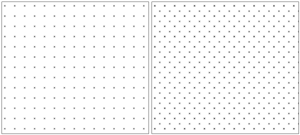
Different point patterns for sampling design
Grid lines created with the type=line option will be identical to the edges of each grid cell, like boundaries with the default type=area option.
The resultant grid can be rotated around the origin (center of the grid) with the angle option.
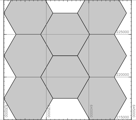
Optionally hexagons can be created with the -h flag. Hexagons are by default symmetric. Asymmetric hexagons can be allowed with the -a flag.
This module is NOT to be used to generate a vector map of USGS quadrangles, because USGS quads are not exact rectangles.
# set the region:
g.region n=90 s=-90 w=-180 e=180 res=10 -p
projection: 3 (Latitude-Longitude)
zone:       0
datum:      wgs84
ellipsoid:  wgs84
north:      90N
south:      90S
west:       180W
east:       180E
nsres:      10
ewres:      10
rows:       18
cols:       36
cells:      648

# create 10 degree size grid:
v.mkgrid map=grid_10deg

# create 20 degree size grid:
v.mkgrid map=grid_20deg box=20,20
v.mkgrid map=coro_grid grid=4,3 position=coor coordinates=2716500,6447000 box=20000,20000
v.mkgrid map=p2min_grid grid=10,12 position=coor coordinates=167:52E,47:06S box=0:02,0:02
g.region raster=elevation res=1000 -pa
v.mkgrid type=point map=pointpattern
# create first set of points, covering extent of "elevation" raster map
g.region raster=elevation res=1000 -pa
v.mkgrid type=point map=pointpattern1

# shift grid by half point distance (map units)
g.region n=n+500 w=w+500 e=e+500 s=s+500 -p

# create second set of points
v.mkgrid type=point map=pointpattern2

# merge into final point pattern
v.patch input=pointpattern1,pointpattern2 output=pointpattern3
g.region raster=elevation res=5000 -pa
v.mkgrid map=hexagons -h

d.grid 5000
Update for new vectors Radim Blazek 10/2004
Last changed: $Date$