OSGeoLive 8.0
An Open Source Geospatial GNU/Linux Distribution

Press "s" for slide notes, ESC to zoom out, SPACE / arrow keys to navigate.
What is OSGeoLive?

- 50+ Open Source Geospatial Applications
- Sample Datasets
- Consistent Overviews & Quickstarts
- Translations
DVD / USB / Virtual Machine

Quality Criteria
- Established, stable, working software
- Active community
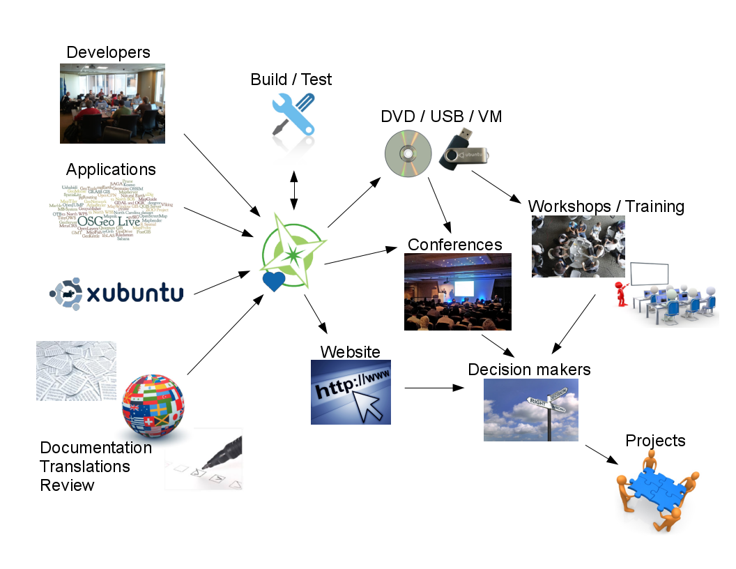
Production & Marketing Pipeline
New in 8.0?
-
Upgraded:
- QGIS, postgis
- cartaro, eoxserver, geonode, geoserver, gvsig, leaflet, mapnik, mapserver, ncwms, osm, otb, pgrouting, pycsw, R, rasdaman, saga, spatialite, zoo-project, zygrib

Open Source Geospatial Foundation (OSGeo)
Since 2006 A Non Profit Umbrella for:
- GeoSpatial Free and Open Source Software
- Education
- Open Data


OGC Standards
- Interoperability
- Future Proof
- Return on Investment
Desktop GIS
General GIS viewing, editing, and analysis on the desktop
| QGIS |
GRASS GIS |
gvSIG |
uDig |
| Kosmo |
OpenJUMP |
SAGA |
QGIS - Desktop GIS
GRASS GIS

gvSIG - Desktop GIS

uDig: User-friendly Desktop Internet GIS

OpenJUMP GIS

Kosmo - Desktop GIS

SAGA - Desktop GIS

Browser Facing GIS
General GIS viewing, editing and analysis in the browser
| OpenLayers |
Leaflet |
Geomajas |
Mapbender |
| GeoMOOSE |
Cartaro |
GeoNode |
OpenLayers - Browser Mapping Library

Leaflet - Mobile Friendly Interactive Maps

Geomajas - Browser GIS Client

Mapbender - Geoportal Framework

GeoMoose - Web GIS Portal

Cartaro - Geospatial CMS

Cartaro provides geospatial functionality and web services within the Drupal Content Management System. With just a few clicks within Cartaro, you can set-up and run OGC standards based web services, as well as build maps into web pages.
GeoNode - Geospatial CMS

GeoNode is a Content Management System for geospatial data which provides creation, sharing, and collaborative use of geospatial data. Datasets can be uploaded, maps and metadata can be edited and published, and user ratings and comments can be captured.
Web Services
Publishing spatial data to the internet
| GeoServer |
MapServer |
deegree |
ncWMS |
| EOxServer |
GeoNetwork |
pycsw |
MapProxy |
| QGIS Server |
52North WPS/SOS |
TinyOWS |
Zoo Project |
GeoServer - Web Services

MapServer - Web Services

deegree - Web Services

ncWMS - Web Map Service

ncWMS publishes multi-dimensional data, such as environmental and weather data, as an OGC compliant Web Map Service.
EOxServer - Web Coverage Service

GeoNetwork - Metadata Catalogue

pycsw - Metadata Catalogue

MapProxy - Proxy WMS & tile services

QGIS Server - Web Map Service

52°North WPS - Web Processing Service

52°North SOS - Sensor Observation Service

ZOO Project - Web Processing Service

Data Stores
Storing spatial data
| PostGIS |
SpatialLite |
| rasdaman |
pgRouting |
PostGIS - Spatial Database

SpatiaLite - Lightweight Database

SpatiaLite adds spatial functionality to the popular SQLite database.
SQLite is a self-contained, zero-administration, relational database, which can pre-built into applications without needing a database server. Each SQLite data store is kept in one file, which can easily be copied between platforms and around the internet without complication.
Rasdaman - Multi-Dimensional Raster Database

pgRouting - routing for PostGIS

Navigation and Maps
| GpsDrive |
GpsPrune |
Marble |
| OpenCPN |
Open Street Map |
Viking |
GpsDrive - GPS Navigation

GpsPrune - View, Edit and Convert GPS Tracks

Marble - Virtual Globe

OpenCPN - Marine GPS Chartplotter

Open Street Map Tools

Viking - GPS Navigation

Spatial Tools
Specific analysis tools
| GeoKettle |
GMT |
Mapnik |
TileMill |
| Maptiler |
OSSIM |
ORFEO Toollbox |
R |
GeoKettle - Extract Transform Load (ETL)

GMT - Generic Mapping Tools

Mapnik - Cartographic Rendering

TileMill - Styling and Publishing

MapTiler - Create Map Tiles

OSSIM - Image Processing

Orfeo Toolbox: Image Processing

R - Statistical Programing

Domain Specific GIS
Applications targeted at a specific domain
| Sahana |
Ushahidi |
osgEarth |
| MB-System |
zyGrib |
Sahana - Disaster Management

Ushahidi - Mapping and Timeline for events

osgEarth - 3D Terrain Rendering

MB-System - Sea Floor Mapping

MB-System processes and displays bathymetry and backscatter imagery data derived from multibeam, interferometry, and sidescan sonars.
zyGrib - Weather Forecast Maps

Data
Spatial data sets
| Natural Earth |
Open Street Map |
| North Carolina |
netCDF |
Natural Earth - Global Data Sets

North Carolina educational dataset

OSM - Sample extract from OpenStreetMap
NetCDF - Time series temperature and precipitation

Geospatial Libraries
| GDAL/OGR |
JTS |
GeoTools |
GEOS |
| MetaCRS Proj4 |
libLAS |
Iris |
GDAL/OGR - Geospatial Data Translation Tools

GDAL and OGR are best known as the vector and raster Geographic Data Abstraction Libraries used by many open source and proprietary applications. However, the functions are also accessible as command line utilities to translate and process a wide range of vector and raster geospatial data formats.
Java Topology Suite

GEOS - C/C++ Spatial Library
![]()
GeoTools

MetaCRS - Coordinate Reference System Transformations
![]()
libLAS - LiDAR Data Access

Iris - Meteorology and Climatology

Other applications
Installers only
| MapWindow |
MapGuide Open Source |
MapGuide - Web Services

MapGuide Open Source is a web-based platform that enables users to develop and deploy web mapping applications and geospatial web services.
MapWindow - Microsoft Windows based Desktop GIS

Credits
Developers and Translators
Core team: Angelos Tzotsos, Cameron Shorter, Hamish Bowman, Alex Mandel and Brian Hamlin.
Sponsors
| OSGeo |
LISAsoft |
UCD ICE |
| NTUA |
DebianGIS |
OSDM |