Morton County Interactive Map Help Page
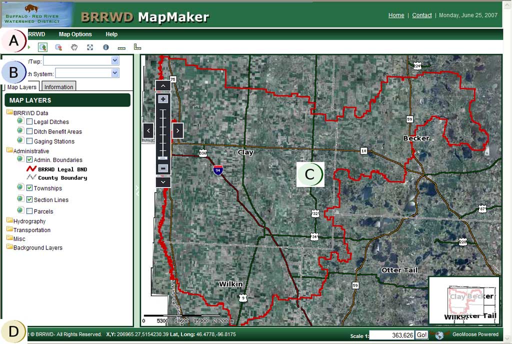
![]() Menubar Drop Down Options
and Toolbar - provides menu items and buttons to use when interacting with
map.
Menubar Drop Down Options
and Toolbar - provides menu items and buttons to use when interacting with
map.
![]() Table of Contents Pane - provides
layer list and information when map is queried.
Table of Contents Pane - provides
layer list and information when map is queried.
![]() Map Pane - this pane
updates when a user turns on/off layers and navigates the map.
Map Pane - this pane
updates when a user turns on/off layers and navigates the map.
![]() Footer Information - provides
information about the map, such as map scale and map coordinates as user moves
the mouse over the map.
Footer Information - provides
information about the map, such as map scale and map coordinates as user moves
the mouse over the map.
Menubar and Toolbar
The menubar provides options to interact with the map. For example, you can toggle the reference map on and off.
The toolbar tools provide options to navigate the map, query the map layers and measure. The individual tools are explained below.
![]() Zoom In Tool -
Clicking on the map will zoom in on the point chosen centering the map on the
point or click and drag to manually define the area to zoom to.
Zoom In Tool -
Clicking on the map will zoom in on the point chosen centering the map on the
point or click and drag to manually define the area to zoom to.
![]() Zoom Out Tool - This tool allows you
to zoom out from a point clicked on the map or click and drag to manually define
the area to zoom to..
Zoom Out Tool - This tool allows you
to zoom out from a point clicked on the map or click and drag to manually define
the area to zoom to..
![]() Pan Map
- This tool allows you to recenter the map without zooming in or out.
Click on the pan tool then click on the map and drag.
Pan Map
- This tool allows you to recenter the map without zooming in or out.
Click on the pan tool then click on the map and drag.
![]() Zoom to Full Extent
- Clicking this button will zoom the map to the full extent.
Zoom to Full Extent
- Clicking this button will zoom the map to the full extent.
![]() Previous Map Extent
- Clicking this button will return you to the previous view.
Previous Map Extent
- Clicking this button will return you to the previous view.
![]() Next Map Extent
- Clicking this button will send you to the next view after you clicked
the previous view button.
Next Map Extent
- Clicking this button will send you to the next view after you clicked
the previous view button.
![]() Identify
- This tool allows you to identify (query) features on the map by clicking it on
the map. The tool will drill down through all visible layers and return
attribute information configured for each map layer. The identify results
are displayed in the table of contents pane.
Identify
- This tool allows you to identify (query) features on the map by clicking it on
the map. The tool will drill down through all visible layers and return
attribute information configured for each map layer. The identify results
are displayed in the table of contents pane.
![]() Measure Length
- This tool allows you to measure a length by drawing a line on the map.
The length is reported back to you in the table of contents.
Measure Length
- This tool allows you to measure a length by drawing a line on the map.
The length is reported back to you in the table of contents.
![]() Measure Area
- This tool allows you to measure an area by drawing a polygon on the
map. The area is reported back to you in the table of contents.
Measure Area
- This tool allows you to measure an area by drawing a polygon on the
map. The area is reported back to you in the table of contents.
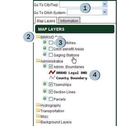
Table of Contents (Map Layers/Legend)
GIS maps are a series of data layers arranged in a way to present geographic data in an easy to read and logical format. A layer of information typically represents only one type of information, for instance on the MMCD map land parcels are one layer of information. When multiple layers are represented we see a map. A GIS map can be used to customize the information seen. In this case we can have the land parcels layer along with lakes and roads layers to create a basic understandable map.
 |
|
The left side of the screen is the table of contents or map layer/legend pane. Here it is possible to turn layers of information on and off on the map by checking and un-checking the box next to the layer name. For instance un-checking the box next to the "Roads and Railways" layer would turn off all roads and railroads on the map, they become invisible. The reverse is also true, checking the box next to "Roads and Railways" will turn on, or make visible, all the roads and railroads on the map.
Clicking on the headings for each information category will hide the layers within it group. For instance clicking on the word "Administrative" will hide or show the Political Boundaries and PLSS layers in the legend window. This is for saving space in the window.
Background images such as 2003 Aerial Photos are available and will cover the background, allowing the user to view information such as roads and parcels while looking at aerial or satellite images. Please note that at some scales the images will lose quality or may not plot on the map. If this is the case try viewing the map at a different scale.
Map Data Sources
All the GIS data used on the map was obtained from Morton County and North
Dakota GIS HUB. For more information about the data please contact the
Morton County Highway Department.
Disclaimer: Morton County does not warrant or guarantee the accuracy of the data. The data is supplied as is. If you have questions regarding the data presented in this web application, please contact the Morton County Highway Department.