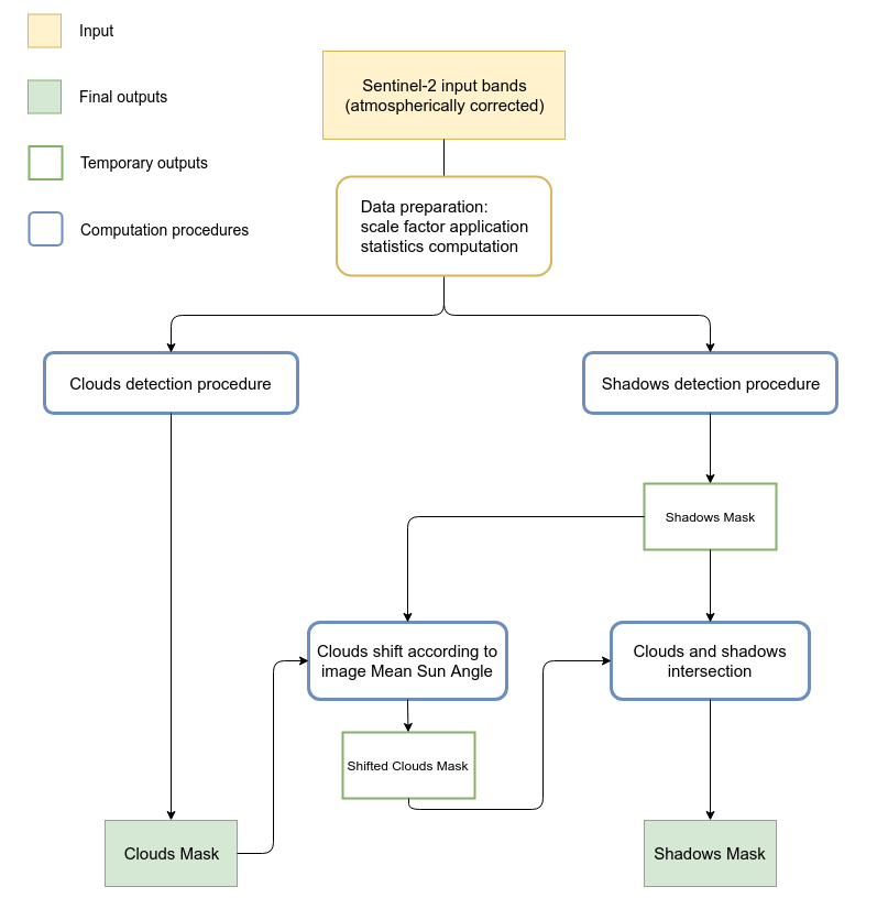
Fig: Module General WorkFlow
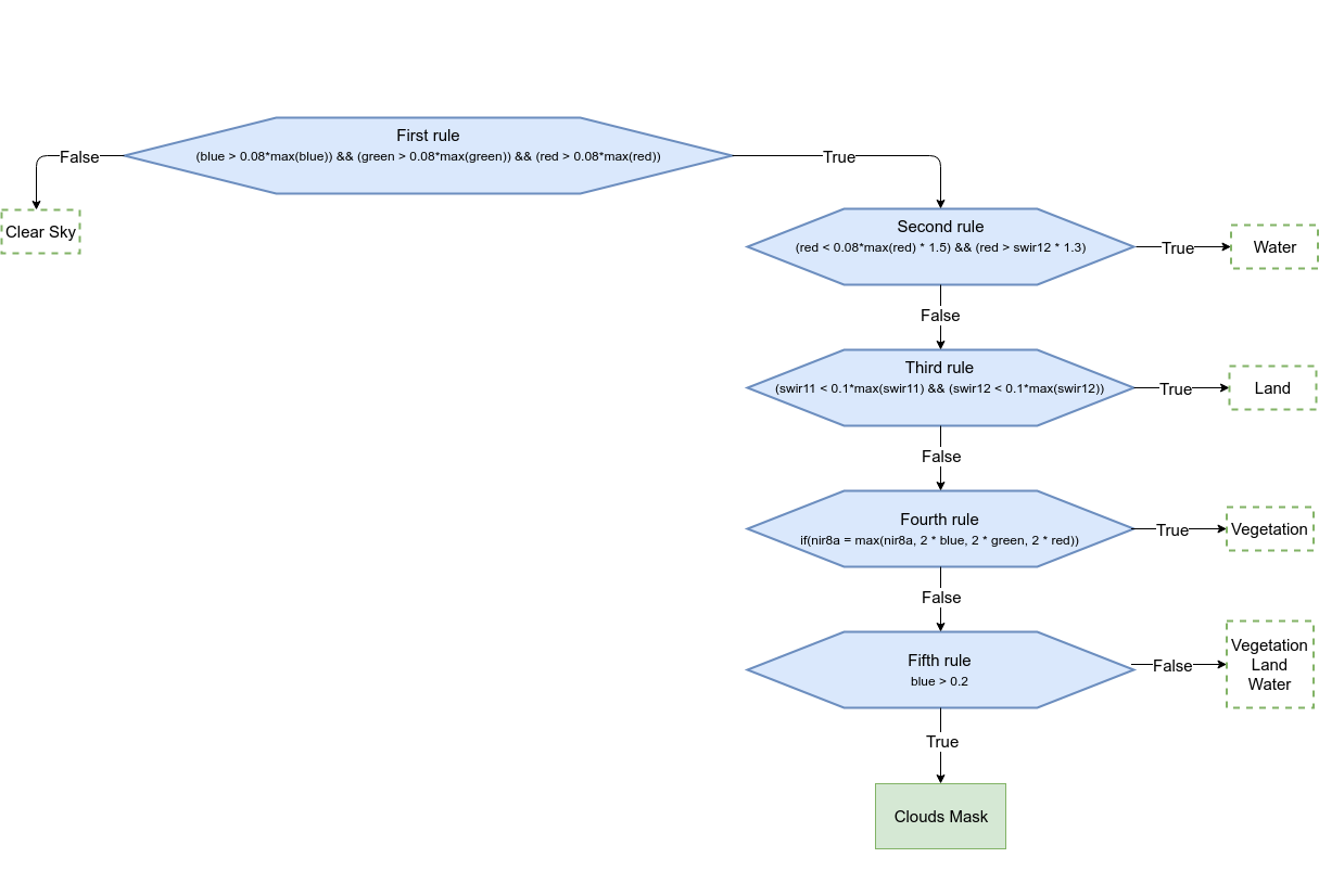
Fig: Cloud detection procedure
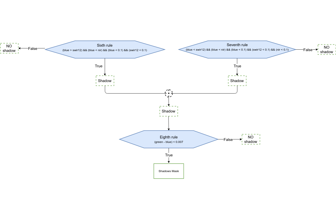
Fig: Shadow detection procedure
The implemented procedure consists essentially of an algorithm based on values thresholds, comparisons and calculations between bands which leads to two different rough maps of clouds and shadows. These require further improvements and elaborations (e.g. transformation from raster to vector, cleaning geometries, removing small areas, checking topology, etc.) carried out in the different steps of the procedure.
Fig: Module General WorkFlow |
Fig: Cloud detection procedure |
Fig: Shadow detection procedure |
The algorithm has been developed starting from rules found in literature (Parmes et. al 2017) and conveniently refined.
Regarding the detection of shadows, the algorithm has been developed to identify only the shadows of clouds on the ground. Obviously, some misclassifications can occur. Often shadows and water have in fact, similar reflectance values which can lead to erroneous classification of water bodies as shadows. Therefore, in order to increase the accuracy of the final shadow mask, a control check is implemented. Clouds and shadows are spatially intersected in order to remove misclassified areas. This means that all those shadow geometries which do not intersect a cloud geometry are removed.
The algorithm works on reflectance values (Bottom of Atmosphere Reflectance) therefore, the atmospheric correction has to be applied to all input bands (see i.sentinel.preproc or i.atcorr)
All necessary input bands (blue, green, red, nir, nir8a, swir11, swir12) must be imported in GRASS and specified one by one or using an input text file. The text file has to be written following the syntax below: variable=your_map
blue=your_blue_map
green=your_green_map
red=your_red_map
nir=your_nir_map
nir8a=your_nir8a_map
swir11=your_swir11_map
swir12=your_swir12_map
The final outputs are two different vector maps, one for clouds and one for shadows.
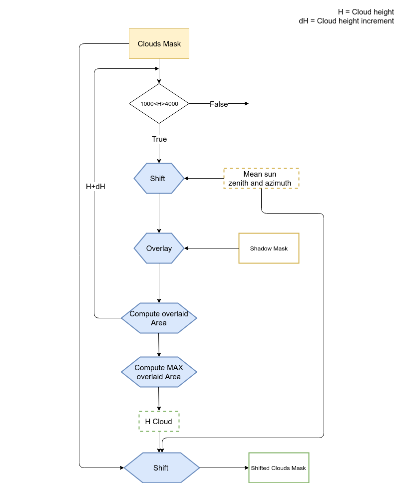
The metadata file (MTD_TL.xml or S2A_OPER_MTD_L1C_TL_MPS__*.xml) is required only if both masks (cloud and shadow) are computed. The module retrieves from this file the sun azimuth and zenith necessary for the shadow mask cleaning phase (see the scheme above)
If flag -s is given all selected bands are rescaled using the specified scale factor [scale_fac=integer]. By default the scale factor is set to 10000, the QUANTIFICATION_VALUE from the metadata of Sentinel-2 images.
The module takes the current region settings into accout. To ignore the current region and set it from the whole image, the flag -r has to be given.
The module allows to compute only the cloud mask or both cloud and shadow masks. If flag -c is given, only the cloud procedure will be performed. The computation of cloud mask is mandatory for shadow mask creation. In fact cloud map is used during the cleaning phase of the shadow mask in order to remove misclassifications.
The example illustrates how to run i.sentinel.mask for a Sentinel-2A image
(S2A_MSIL1C_20180713T155901_N0206_R097_T17SPV_20180713T211059.SAFE) in the
North Carolina location.
Obviously, the image has been imported and
atmospheric correction has been performed before running i.sentinel.mask .
i.sentinel.mask -r input_file=path/input_cloud_mask.txt cloud_mask=cloud shadow_mask=shadow cloud_threshold=25000 shadow_threshold=5000 mtd_file=path/MTD_TL.xml
The input text file:
blue=T17SPV_20180315T160021_B02_cor
green=T17SPV_20180315T160021_B03_cor
red=T17SPV_20180315T160021_B04_cor
swir11=T17SPV_20180315T160021_B11_cor
nir=T17SPV_20180315T160021_B08_cor
swir12=T17SPV_20180315T160021_B12_cor
nir8a=T17SPV_20180315T160021_B8A_cor
Use -r to set the computational region to the maximum image extend.

i.sentinel.download, i.sentinel.import, i.sentinel.preproc, r.import, r.external
Last changed: $Date$