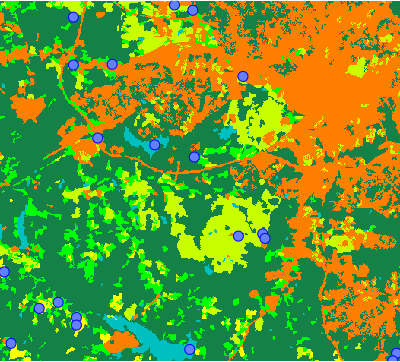
Figure: Three random points in each category of landclass raster map
r.sample.category generates points at random locations. Each category (class) in a raster map will contain specified number of random points.
Different number of points can be specified for different categories. For example, if there are categories 1, 4, 7 in the input raster map, and npoints=100,200,300, 100 points will be generated in category 1, 200 points in category 4 and 300 points in category 7. If only one number is specified, it will be used for every category.
Categories are identified based on current computational region.
g.region raster=landclass96
r.sample.category input=landclass96 output=landclass_points npoints=3
d.rast map=landclass96
d.vect map=landclass_points icon=basic/circle fill_color=aqua color=blue size=10
r.sample.category input=landclass96 output=landclass_points sampled=elevation,geology_30m npoints=2
v.db.select landclass_points sep=comma
cat,landclass96,elevation,geology_30m
1,1,102.7855,270
2,1,105.78,270
3,2,114.5954,217
4,2,137.4816,921
5,3,71.19167,270
6,3,93.33904,270
7,4,76.41077,262
8,4,97.54424,217
9,5,138.455,405
10,5,88.8075,270
11,6,126.5298,217
12,6,86.73177,217
13,7,134.5381,217
14,7,99.6844,270
Vaclav Petras, NCSU OSGeoREL,
Anna Petrasova, NCSU OSGeoREL
Last changed: $Date$