DESCRIPTION

r.shaded.pca is a tool for the generation of RGB composite of the three main components of PCA created from different hill shades (created by r.relief).

Input parameters explanation

Input parameters are the same as for r.relief module except for an azimuth parameter which is replaced by nazimuths parameter (we need to specify number of different azimuths rather than one) and for an nprocs parameter which adds the possibility to run the shades creation (r.relief) in parallel. However, the speed of i.pca limits the overall speed of this module. In order to provide simple interface, it is not possible to customize principal component analyses which uses the default settings of the i.pca module.

Output parameters explanation

The the standard output map is an RGB composition of first three principal components where components are assigned to red, green and blue colors in this order. If you want to create your own RGB composition, HIS composition or do another analyses you can specify the pca_shades_basename parameter. If this parameter is specified, the module outputs the PCA maps as created during the process by i.pca. Moreover, if you would like to add one of the shades to your composition, you can specify the shades_basename parameter then the module will output also the hill shade maps as created during the process by r.relief. One of the shades can be used to subtract the intensity channel in HIS composition or just as an overlay in your visualization tool.

EXAMPLE

# basic example with changed vertical exaggeration
r.shaded.pca input=elevation output=elevation_pca_shaded zscale=100

# example of more complicated settings
# including output shades and principal component maps
r.shaded.pca input=elevation output=elevation_pca_shaded \
 zscale=100 altitude=15  nazimuths=16 nprocs=4 \
 shades_basename=elevation_pca_shaded_shades pca_shades_basename=elevation_pca_shaded_pcs
3 PCA RGB composition

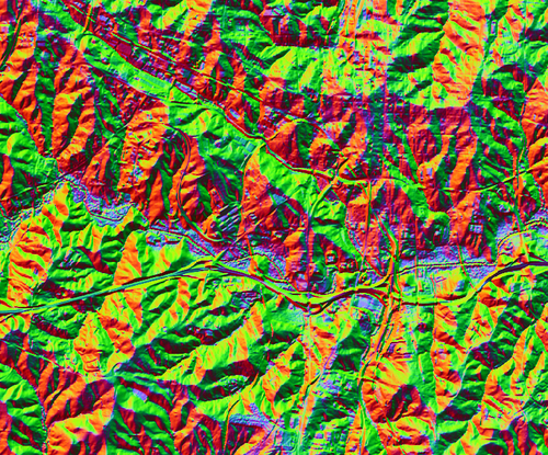
Figure: The RGB composition of first 3 PCA components (output from r.shaded.pca with default values)

SEE ALSO

r.relief, i.pca, r.local.relief, r.skyview

REFERENCES

Devereux, B. J., Amable, G. S., & Crow, P. P. (2008). Visualisation of LiDAR terrain models for archaeological feature detection. Antiquity, 82(316), 470-479.

AUTHOR

Vaclav Petras, NCSU OSGeoREL

Last changed: $Date$