DESCRIPTION
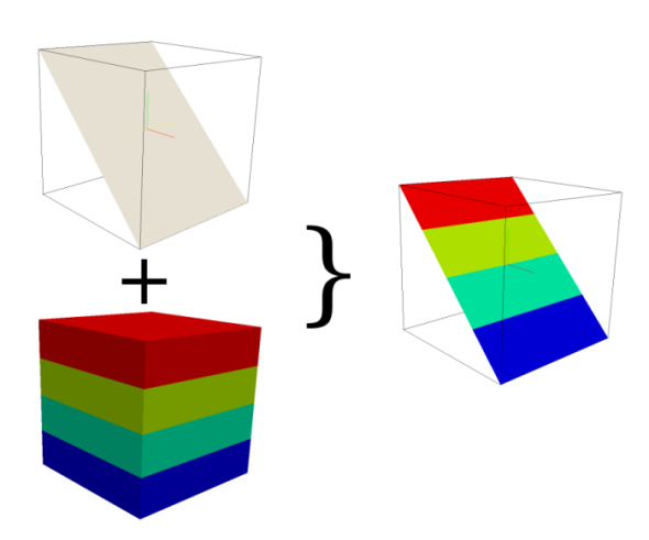
This module creates a cross section 2D map from one 3D raster volume
map based on a 2D elevation map. It checks if the value of the
elevation map is located in the z-coordinate space of the 3D map. If
so, the 3D voxel value for this position is transferred to the related
cross section output map cell, otherwise the NULL value is set.
If the 2D and 3D region settings are different,
the 2D resolution will be adjust to the 3D resolution.
NOTES
To create a cut plane elevation map use r.mapcalc. Some examples:
- To create a cut plane elevation map in x direction type
r.mapcalc "cutplane = col()*x",
x be the value for
the elevation. If the range of col() is 1 ... 10, the elevation map
has the range 1 ... 10 if x == 1 and if x == 10 the range 10
... 100
- To create a cut plane elevation map in y direction type
r.mapcalc "cutplane = row()*x",
x be the value for
the elevation. If the range of col() is 1 ... 10, the elevation map
has the range 1 ... 10 if x == 1 and if x == 10 the range 10
... 100
- The user can also make a cut in y and x direction with r.mapcalc by
using
r.mapcalc "cutplane = (row()+col())*x"
EXAMPLE
Simple Spearfish example
g.region -d
g.region res=150 res3=150 t=1000 b=0 tbres=100

# synthetic data, could be geological structures:
r3.mapcalc "map3d = sin(row())+sin(col())+sin(depth()*depth())"

#create a cutplane map
r.mapcalc "cutplane = col()*10"

#create the cross section map
r3.cross.rast input=map3d elevation=cutplane output=crosssection
SEE ALSO
g.region,
r.mapcalc,
r3.mapcalc,
r3.to.rast
AUTHOR
Sören Gebbert
Last changed: $Date$