DESCRIPTION
i.topo.corr is used to topographically correct reflectance
from imagery files, e.g. obtained with i.landsat.toar, using a
sun illumination terrain model. This illumination model represents the
cosine of the incident angle i, i.e. the angle between the normal to the
ground and the sun rays.
Note: If needed, the sun position can be calculated for a given date with
r.sunmask.
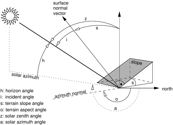
Figure showing terrain and solar angles
Using the -i flag and given an elevation basemap (metric),
i.topo.corr creates a simple illumination model using the formula:
- cos_i = cos(s) * cos(z) + sin(s) * sin(z) * cos(a - o)
where,
i is the incident angle to be calculated,
s is the terrain slope angle,
z is the solar zenith angle,
a the solar azimuth angle,
o the terrain aspect angle.
For each band file, the corrected reflectance (ref_c) is calculate from
the original reflectance (ref_o) using one of the four offered methods
(one lambertian and two non-lambertian).
Method: cosine
- ref_c = ref_o * cos_z / cos_i
Method: minnaert
- ref_c = ref_o * (cos_z / cos_i) ^k
where,
k is obtained by linear regression of
ln(ref_o) = ln(ref_c) - k ln(cos_i/cos_z)
Method: c-factor
- ref_c = ref_o * (cos_z + c)/ (cos_i + c)
where,
c is a/m from ref_o = a + m * cos_i
Method: percent
We can use cos_i to estimate the percent of solar incidence on the surface,
then the transformation (cos_i + 1)/2 varied from 0
(surface in the side in opposition to the sun: infinite correction) to 1
(direct exhibition to the sun: no correction) and the corrected reflectance can
be calculated as
- ref_c = ref_o * 2 / (cos_i + 1)
NOTES
- The illumination model (cos_i) with flag -i uses the actual region
as limits and the resolution of the elevation map.
- The topographic correction use the full reflectance file (null remain
null) and its resolution.
- The elevation map to calculate the illumination model should be metric.
EXAMPLES
First, make a illumination model from the elevation map (here, SRTM). Then
make perform the topographic correction of e.g. the bands toar.5, toar.4 and toar.3
with output as tcor.toar.5, tcor.toar.4, and tcor.toar.3 using c-factor (= c-correction)
method:
# first pass: create illumination model
i.topo.corr -i base=SRTM zenith=33.3631 azimuth=59.8897 output=SRTM.illumination

# second pass: apply illumination model
i.topo.corr base=SRTM.illumination input=toar.5,toar.4,toar.3 output=tcor \
  zenith=33.3631 method=c-factor
REFERENCES
- Law K.H. and Nichol J, 2004. Topographic Correction For Differential
Illumination Effects On Ikonos Satellite Imagery. International Archives of
Photogrammetry Remote Sensing and Spatial Information, pp. 641-646.
- Meyer, P. and Itten, K.I. and Kellenberger, KJ and Sandmeier, S. and
Sandmeier, R., 1993. Radiometric corrections of topographically induced
effects on Landsat TM data in alpine terrain. Photogrammetric Engineering
and Remote Sensing 48(17).
- Riaño, D. and Chuvieco, E. and Salas, J. and Aguado, I., 2003.
Assessment of Different Topographic Corrections in Landsat-TM
Data for Mapping Vegetation Types. IEEE Transactions On Geoscience
And Remote Sensing, Vol. 41, No. 5
- Twele A. and Erasmi S, 2005. Evaluating topographic correction algorithms
for improved land cover discrimination in mountainous areas of
Central Sulawesi. Göttinger Geographische Abhandlungen, vol. 113.
SEE ALSO
i.landsat.toar,
r.mapcalc,
r.sun
r.sunmask
AUTHOR
E. Jorge Tizado (ej.tizado unileon es)
Dept. Biodiversity and Environmental Management, University of León, Spain
Figure derived from Neteler & Mitasova, 2008.
Last changed: $Date$