DESCRIPTION
v.select allows the user to select features from a vector
map by features from another one.
Supported operators (without GEOS; using GRASS' own algorithm):
- overlap - features partially or completely overlap (GEOS equivalent: intersects)
Supported operators (internally using
GEOS - Geometry Engine, Open Source):
- equals - features are spatially equals
- disjoint - features do not spatially intersect
- intersects - features spatially intersect (equivalent to native 'overlap')
- touches - features spatially touches
- crosses - features spatially crosses
- within - feature A is completely inside feature B
- contains - feature B is completely inside feature A
- overlaps - features spatially overlap
- relate - feature A is spatially related to feature B
NOTES
Only features with category numbers will be considered. If required
the v.category module can be
used to add them. Typically boundaries do not need to be given a
category number, as an area's attributes are inherited from the
centroid. Typically points, lines, and centroids will always want to
have a cat number. E.g. take a road which separates two farms. It is
ambiguous as to which farm an attribute that is attached to the road
belongs to. The boundary only needs a cat number if it will hold its
own attributes, such as road name or pavement form. A centroid in each
paddock holds the information with respect to ownership, area, etc.
EXAMPLES
Preparation of example data (North Carolina sample dataset):
# Create an grid for overlaying to ZIP code vector map
v.mkgrid map=boxgrid grid=10,10 position=coor \
         coordinates=583600,201500 box=5000,5000

# set region to ZIP codes and boxgrid vector maps
g.region vector=zipcodes_wake,boxgrid -p res=100 -a
# enlarge region a bit for "white border" around map in monitor
g.region n=n+1000 s=s-1000 w=w-1000 e=e+1000 -p
d.mon wx0
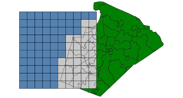
OVERLAP: features partially or completely overlap (using GRASS)
Select grid boxes (North Carolina sample dataset):
d.vect map=zipcodes_wake fill_color=0:128:0
d.vect map=boxgrid fill_color=85:130:176
v.select ainput=boxgrid binput=zipcodes_wake output=v_select_OVERLAP operator=overlap
d.vect map=v_select_OVERLAP
d.vect map=zipcodes_wake type=boundary color=50:50:50

v.select with OVERLAP operator: selected grid boxes shown in grey
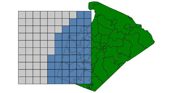
OVERLAPS features spatially overlap (using GEOS)
Select grid boxes (North Carolina sample dataset):
d.vect map=zipcodes_wake fill_color=0:128:0
d.vect map=boxgrid fill_color=85:130:176
v.select ainput=boxgrid binput=zipcodes_wake output=v_select_OVERLAPS operator=overlaps
d.vect map=v_select_OVERLAPS
d.vect map=zipcodes_wake type=boundary color=50:50:50
v.select with OVERLAPS operator: selected grid boxes shown in grey
DISJOINT: features do not spatially intersect (using GEOS)
Select grid boxes (North Carolina sample dataset):
d.vect map=zipcodes_wake fill_color=0:128:0
d.vect map=boxgrid fill_color=85:130:176
v.select ainput=boxgrid binput=zipcodes_wake output=v_select_DISJOINT operator=disjoint
d.vect map=v_select_DISJOINT
d.vect map=zipcodes_wake type=boundary color=50:50:50
v.select with DISJOINT operator: selected grid boxes shown in grey
EQUALS: features are spatially equals (using GEOS)
Select zipcode polygon (North Carolina sample dataset):
d.vect map=zipcodes_wake fill_color=0:128:0
v.extract input=zipcodes_wake where=ZIPCODE_ID=35 output=zipcodeID35
v.select ainput=zipcodes_wake binput=zipcodeID35 output=v_select_EQUALS operator=equals
d.vect map=v_select_EQUALS
d.vect map=zipcodes_wake type=boundary color=50:50:50

v.select with EQUALS operator: selected grid boxes shown in grey
INTERSECTS: features spatially intersect (using GEOS)
Select zipcode polygons (North Carolina sample dataset):
d.vect map=zipcodes_wake fill_color=0:128:0
d.vect map=boxgrid fill_color=85:130:176
v.select ainput=zipcodes_wake binput=boxgrid output=v_select_INTERSECTS operator=intersects
d.vect map=v_select_INTERSECTS
d.vect map=boxgrid type=boundary color=50:50:50
v.select with INTERSECTS operator: selected grid boxes shown in grey
TOUCHES: features spatially touches (using GEOS)
Select polygons (North Carolina sample dataset):
d.vect map=zipcodes_wake fill_color=0:128:0
d.vect map=zipcodeID35 fill_color=85:130:176
v.select ainput=zipcodes_wake binput=zipcodeID35 output=v_select_TOUCHES operator=touches
d.vect map=v_select_TOUCHES
d.vect map=zipcodes_wake type=boundary color=50:50:50
v.select with TOUCHES operator: selected polygons shown in grey (blue: input polygon)
CROSSES: features spatially crosses (using GEOS)
Select zipcode polygons by lines (North Carolina sample dataset):
d.vect map=zipcodes_wake fill_color=0:128:0
d.vect map=busroute1 color=200:27:27 width=3
v.select ainput=zipcodes_wake binput=busroute1 output=v_select_CROSSES operator=crosses
d.vect map=v_select_CROSSES
d.vect map=zipcodes_wake type=boundary color=50:50:50
d.vect map=busroute1 color=200:27:27 width=3
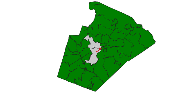
v.select with CROSSES operator: selected polygons shown in grey (red: input lines)
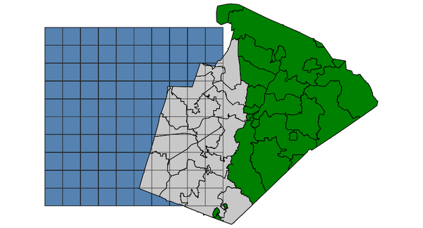
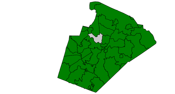
WITHIN feature A is completely inside feature B (using GEOS)
Select zipcode polygons (North Carolina sample dataset):
d.vect map=zipcodes_wake fill_color=0:128:0
d.vect map=boundary_county fill_color=85:130:176
v.select ainput=zipcodes_wake binput=boundary_county output=v_select_WITHIN operator=within
d.vect map=v_select_WITHIN
v.select with WITHIN operator: selected polygons shown in grey (blue: input polygons)
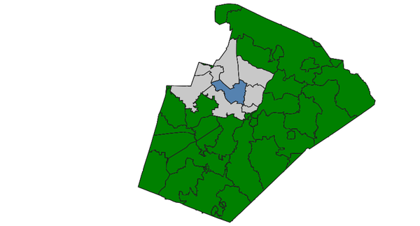
CONTAINS feature B is completely inside feature A (using GEOS)
Select zipcode polygon (North Carolina sample dataset):
CONTAINS with polygons
d.vect map=zipcodes_wake fill_color=0:128:0
d.vect map=zipcodeID35 fill_color=85:130:176
v.select ainput=zipcodes_wake binput=zipcodeID35 \
         output=v_select_CONTAINS_pol operator=contains
d.vect map=v_select_CONTAINS
v.select with CONTAINS operator: selected polygon shown in grey (blue: input polygon, not visible)
CONTAINS with points
d.vect map=zipcodes_wake fill_color=0:128:0
d.vect map=hospitals fill_color=195:31:31 icon=basic/cross3 size=10
v.select ainput=zipcodes_wake binput=hospitals \
         output=v_select_CONTAINS_pnts operator=contains
d.vect map=v_select_CONTAINS_pnts
d.vect map=hospitals fill_color=195:31:31 icon=basic/cross3 size=10
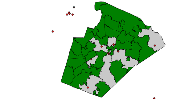
v.select with CONTAINS operator: selected polygons shown in grey (red: input points)
RELATE feature A is spatially related to feature B (using GEOS)
This operator additionally requires the relate parameter (in other
GIS called 'ST_Relate').
This operator allows calculating the
Dimensionally Extended nine-Intersection Model (DE-9IM).
In the following one example: Select polygon with 'TOUCHES' operator
(North Carolina sample dataset):
d.vect map=zipcodes_wake fill_color=0:128:0
d.vect map=zipcodeID35 fill_color=85:130:176
v.select ainput=zipcodeID35 binput=zipcodes_wake \
         output=v_select_TOUCHES_relate operator=relate relate='T********'
d.vect map=v_select_TOUCHES
Extraction of points falling into a polygon
Extract fire stations (points) falling into urban area (polygon) - North Carolina
data set (point in polygon test):
v.select ainput=firestations binput=urbanarea output=urban_firestations \
         operator=overlap
Extraction of lines overlapping with a polygon
Extract railroad lines from zip code map overlapping with the urban area
(line in polygon test):
v.select ainput=railroads binput=urbanarea \
         output=railroads_in_urbanarea operator=overlap
Extraction of areas overlapping with a line
Extract those areas from zip code map which overlap with railroads
(polygon on line test):
# first add a tiny buffer around railroad lines:
v.buffer input=railroads output=railroads_buf20m \
  distance=20

v.select ainput=zipcodes_wake binput=railroads_buf20m \
  output=zipcodes_wake_railroads operator=overlap
SEE ALSO
v.category,
v.clip,
v.overlay,
v.extract
GRASS SQL interface
GEOS - Geometry Engine, Open Source
AUTHORS
Radim Blazek
GEOS support by Martin Landa, Czech Technical University in Prague, Czech Republic
ZIP code examples by Carol X. Garzon-Lopez, Trento, Italy
Last changed: $Date$