r.li.shannon
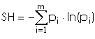
calculates the "shannon's diversity index" as:
with:
i: patch type
m: number of patch type
pi: proportion of the landscape occupied by patch type i
REFERENCES
McGarigal, K., and B. J. Marks. 1995. FRAGSTATS: spatial pattern
analysis program for quantifying landscape structure. USDA For. Serv.
Gen. Tech. Rep. PNW-351.
EXAMPLES
To calculate shannon's diversity index on map my_map, using
my_conf configuration file and saving results in my_out file run:
Do not use absolute path names for output files. They are raster if
moving window disposition was selected, otherwise they are in
~/.r.li/output folder.
If input raster is full of null values r.li.shannon returns -1.
If you want to have null values instead run