r.li.cwed (contrast weighted edge density) calculates the edge density
between patch types specified:
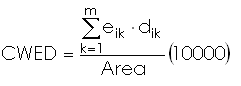
with:
k: attribute
m: number of non-null attributes in the sampling area
eik: total length of edge in landscape between patch types i and k
dik: dissimilarity (edge contrast weight) between patch types i and k
Area: total landscape area
The input file have a row for each couple of patch type that we want to
consider in the calculation. Each row must to have this syntax:
patchType1,patchType2,dissimilarityBetweenPatchType1andPatchType2
EXAMPLES
To calculate mean pixel attribute index on map my_map, using
my_conf configuration file and saving results in
my_out file run:
Example of input file:
12,16,0.65
44,123,0.32
56,12,0.54
23,66,0.99
NOTES
Do not use absolute path names for output files. They are raster if
moving window disposition was selected, otherwise they are in
~/.r.li/output folder.
If the raster is full of null value it is considered to have 0 patch and CWED=0.
If Area is 0 r.li.cwed returns -1. This is possible
only if the map is masked.
If you want to have null values instead run
r.null setnull=-1 map=my_map
after index calculation.
REFERENCES
McGarigal, K., and B. J. Marks. 1995. FRAGSTATS: spatial pattern
analysis program for quantifying landscape structure. USDA For. Serv.
Gen. Tech. Rep. PNW-351.