DESCRIPTION
wxGUI is a new generation of the GUI for GRASS GIS. It's a successor
of the Tcl/Tk GUI.
To start the wxGUI automatically for each session run GRASS with
wxpython switch
or define in your .grassrc6 file 'GRASS_GUI' variable
The GUI can be quit by selecting the 'File->Exit' menu item. The GUI
can be restarted from the GRASS command line prompt by
typing
or
g.gui wxpython workspace=file.gxw
The GUI is composed by two main components:
- Layer Manager which allows users to run different GRASS
modules from menu, includes map layer management, integrated
command-line prompt, and command output window tab.
- Map Display Window which integrates basic tools for
zooming, panning, data querying, decorations (north arrows,
barscale, etc.). The user is allowed to start various map display
instances during one session. The Layer Manager registers Map
Display Windows using different tabs.
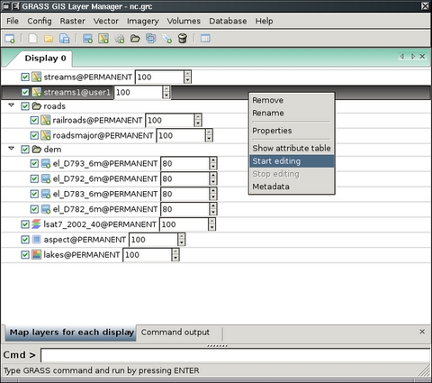
Layer Manager
The Layer Manager provides an interactive graphical interface to GRASS
commands. It includes a set of pull-down menus for all GRASS GIS
functions (analysis, file I/O, GIS configuration and management), the
toolbar to manage display map layers, a layer tree frame in which map layers
to display are organized, command output window tab, and interactive
command line prompt.
The top left button of the toolbar opens a new Map Display
Window. Each map display has a unique set of layers to display
and region settings. Other toolbar buttons add layers of different
types for display in the selected map display window. There are
additional buttons for saving or opening workspace file, and others.
Map layers are listed in the window frame below the toolbar. Layers can
include raster and vector maps, text, map decorations (scale and
north arrow, and grids), and commands (where any GRASS command can be
written). Layers are displayed in as arranged in the layer tree: the
bottom layer is displayed first and the top is displayed last, as if
layers are a series of stacked overlays.
The check box to the left of each layer makes it active or inactive
for display. Only active layers are displayed/redisplayed when the
display button is pressed. Layers can be organized into groups; entire
groups can be activated or deactivated for display. Layer tree
composition can be saved to a workspace file and opened in subsequent
sessions, restoring all layers and their display options.
Layer Manager Toolbar


 Open new Map Display Window
- Opens a new map display and creates empty layer tree tab in Layer Manager.


 Creates new workspace file
- Removes all layers in the layer tree and creates a new, empty tree
where new layers can be added.

 Load map layers (raster, vector) into workspace
- Loads selected raster or vector maps into current layer tree.


 Open an existing workspace file
- Opens an previously saved workspace file, containing a set of display
layers and their option settings.


 Save layers composition to workspace
file
Save layers composition to workspace
file- Saves current set of layers and their options to a workspace
file.


 Add raster-based map layer
- Adds raster map to layer tree, see d.rast. Includes also shaded relief map, RGB or HIS map or raster flow arrows map.


 Add shaded relief map layer
- Adds shaded relief raster map layer,
see d.shadedmap.


 Add RGB raster layer
- Combines and displays three raster maps defined as red, green, and blue
channels, see d.rgb.


 Add HIS raster layer
- Combines and displays two or three raster maps defined as hue,
intensity, and (optionally) saturation channels,
see d.his.


 Add raster arrows layer
- Adds map of raster cells with directional arrows drawn. Arrow
direction and length are determined by separate aspect/directional map
and (optional) slope/intensity map,
see d.rast.arrow.


 Add vector-based map layer
- Adds a vector map layer, see d.vect. Includes also thematic vector map or thematic charts layer.


 Add thematic map layer
(for all vector types)
Add thematic map layer
(for all vector types)- Adds layer for thematic display values from a numeric attribute
column associated with a vector map. Options include: thematic display
type (graduated colors or point sizes), methods for creating display
intervals, SQL query of attribute column to limit vector objects to
display, control of point icon types and sizes, control of thematic
color schemes, creation of legend for thematic map, and saving the
results of thematic mapping to a ps.map instructions file for later
printing,
see d.vect.thematic.


 Add thematic charts layer
(for vector points)
Add thematic charts layer
(for vector points)- Adds layer in which pie or bar charts can be automatically created
at vector point locations. Charts display values from selected columns
in the associated attribute table. Options include: chart type, layer
and attributes to chart, chart colors, and chart size (fixed or based
on attribute column),
see d.vect.chart.


 Add command layer
- Adds a layer in which a GRASS GIS command or command list can be entered.
For a command list use the semi-colon (";") symbol as a separator.
For example:
d.rast soils;d.rast -o roads;d.vect streams col=blue
d.text text=Population\ density


 Add layer group
- Adds an empty layer group. Layers can then be added to the group.


 Add overlay grids and lines
- Adds layer to display regular grid (for all locations), or geodesic and
rhumblines (for latitude/longitude locations only), see d.grid, d.geodesic, d.rhumbline.


 Add labels layer for vector
objects (from existing labels file)
Add labels layer for vector
objects (from existing labels file)- Add raster text layer from a labels file for vector objects
created with the v.label module
(accessed from button in options panel). A labels file can also be
created with a text editor,
see d.labels.


 Remove map layer from layer tree
- Removes selected map layer or map layer group from layer tree.


 Open Attribute Table Manager for selected vector map
- Displays attribute data of selected vector map.
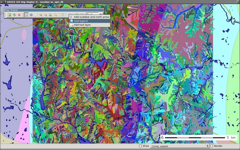
Map Display Window
This component includes toolbar area (set of toolbars), map canvas
where a map composition is displayed, and the statusbar.
Each Map Display Window has a unique layer tree and region
setting. The window contains a toolbar with buttons to manage the map
in the display (zoom and pan), providing tools for query and distance
measurement, and exporting or printing the display.
In the statusbar can be displayed the geographic coordinates under the
cursor, current geographical region extent, computational region
(including graphical visualization in map display), map display
geometry (number of rows, columns, resolution) and map scale.
It is important to note that zooming in any display will
have no effect on the 'computational region' setting (set
with g.region). Only by selecting
the 'Set current region to match display' item in the zoom menu (in
the map display toolbar) will the current display extents be copied to
the computational region extents.
Map Display Toolbar


 Display active layers (current region)
- Displays all active layers from layer tree at current resolution
and region extents for that map display window.


 Re-render and display all active
layers and zoom to current region
Re-render and display all active
layers and zoom to current region- Resets the region to the display resolution and extents and forces
re-display and re-rendering all active layers.


 Erase display content
- Erases the currently selected map display to a white background;
also removes all frames,
see d.erase, d.frame
-e.


 Arrow cursor
- Select arrow cursor for map display.


 Query tool (select a map first)
- Query selected raster, RGB raster (all three map channels will be
queried), or vector map(s) using the mouse. Map(s) must be selected
before query. Vector charts and thematic vector maps cannot be
queried. The results of the query will be displayed in the console
window,
see r.what, v.what.

 Pan
Pan- Interactive selection of a new center of view in the active
display monitor. Drag the pan cursor while pressing the left mouse
button to pan. Panning changes the location of the region displayed
but not the size of the area displayed or the resolution. Panning
does not affect the computational region for other GIS
processes, see g.region.


 Zoom in
- Interactive zooming with the mouse in the active display monitor.
Drawing a box or just click with the mouse (left button) and zoom-in
cursor causes the display to zoom in so that the area defined by the
box fills the display. The map resolution is not changed. Clicking
with the zoom-in cursor causes the display to zoom in by 30%, centered
on the point where the mouse is clicked. Zooming resets the display
region extents (both size and location of area displayed). It
does not affect the computational region for other GIS
processes, see g.region.


 Zoom out
- Interactive zooming with the mouse in the active display monitor.
Drawing a box or just click with the mouse (left button) and zoom-out
cursor causes the display to zoom in so that the area displayed
shrinks to fill the area defined by the box. The map resolution is not
changed. Clicking with the zoom-out cursor causes the display to zoom
out by 30%, centered on the point where the mouse is clicked. Zooming
resets the display region extents (both size and location of area
displayed). It does not affect the computational region for
other GIS processes,
see g.region.


 Revert zoom
- Returns to the previous zoom. Up to 10 levels of zoom back are
maintained, see g.region.


 Zoom menu
- Automatic zoom settings menu. Zoom to match the extents of a selected
map, zoom to match the computational region (set with
g.region), zoom to match the extents of a saved region or
save the current extents to a named region file, or to set
computational region (the mapset's WIND file) to match the
current display extents (does not change the resolution).
See g.region.


 Analyze menu
- Contains functions for distance measurement, creating histogram or
profile tool.


 Distance measurement tool
- Interactive measurement of lengths defined with the mouse. The
length of each segment and the cumulative length of all segments
measuered is displayed in the command output window frame. Lengths are
measured in the current measurement unit,
see d.measure.


 Profile tool
- Interactively create profile of a raster map. Profile transect is
drawn with the mouse in map display. The profile may be of the
displayed map or a different map,
see Profile Tool help
page.

 Display histogram of selected raster map
- Displays histogram of selected raster map or image in new window,
see d.histogram.

 Add overlay
- Adds overlay to map display like barscale, north arrow, text.


 Add scalebar and north arrow
- Adds layer to display a combined scalebar and north arrow. Options
include scalebar placement (using screen coordinates or a mouse),
scalebar format, and scalebar colors,
see d.barscale.


 Add raster map legend
- Adds layer to display with legend of selected raster map,
see d.legend.


 Add text layer
- Adds layer to display a line of text using default GRASS font
(selected with d.font). Options
include: text placement (screen coordinates); and text size, bolding,
and color, see d.text.

 Export map display
- Exports visible map display to different raster graphic formats.


 Print map
- Prints map on the UNIX lpr printer or PostScript device;
saves visible map display (including PostScript text and labels) to PDF
or EPS file. Requires ghostscript for all output except EPS.
CONFIGURATION
User preferences dialog ('Config->Preferences') enables configuration
of various options.
Icon Theme
Currently are supported three icon theme sets:
SEE ALSO
Vector digitizing tool,
Attribute Table Manager,
Nviz extension
See also Wiki page.
TCL/TK-based GIS Manager,
TCL/TK-based Display Manager
AUTHORS
(Alphabetically ordered)
Michael Barton,
Daniel Calvelo Aros,
Jachym Cepicky,
Martin Landa, FBK-irst, Trento, Italy
$Date$