DESCRIPTION
r.li.edgedensity calculates:
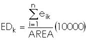
- the density of all the edge of patch i
or
- the density of all the edge in the sampling area if i isn't specified
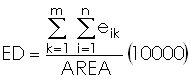
with:
- k: patch type
- m: number of patch type
- n: number of edge segment of patch type k
- eik :total length of edge in landscape involving patch type k
- Area: total landscape area
REFERENCES
McGarigal, K., and B. J. Marks. 1995. FRAGSTATS: spatial pattern
analysis program for quantifying landscape structure. USDA For. Serv.
Gen. Tech. Rep. PNW-351.
EXAMPLES
To calculate edge density index on map my_map, using
my_conf configuration file and saving results in
my_out file run:
r.li.edgedensity map=my_map conf=my_conf output=my_out
r.li.edgedensity map=my_map conf=my_conf output=my_out patch_type=34
NOTES
Do not use absolute path names for output files. They are raster if
moving window disposition was selected, otherwise they are in
~/.r.li/output folder.
If input raster is full of null values r.li.edgedensity consider to have 0
patch.
If area is 0 r.li.edgedensity returns -1; this is possible only if input
raster is masked.
If you want to have null values instead run
r.null setnull=-1 map=my_map
SEE ALSO
r.li
AUTHORS
Serena Pallecchi student of Computer Science University of Pisa (Italy).
Commission from Faunalia Pontedera (PI), Italy (www.faunalia.it)
BUGS
Please send bugs reports to
pallecch@cli.di.unipi.it
Last changed: $Date$