DESCRIPTION
r.in.wms handles all of downloading and importing raster data
from an OGC
WMS web mapping server. It need only be told the desired data to
collect (bounds and resolution) via a region, the server to get the
data from, and the layer or layers to get. It downloads the data in
tiles, reprojects it, imports it, and patches it back together.
NOTES
By default data is downloaded to $GISDBASE/wms_download. This can be changed
by setting the folder option when using r.in.wms.
To understand the data you are getting it is necessary to look at the
capabilities of the WMS server. This should be available via a capabilities
request. This is an
example
capabilities request to NASA's OnEarth server.
Other brain-dead servers will not accept queries in the form of POST data.
If you get an error try using the -g flag to force r.in.wms
to send an atomic GET request instead.
EXAMPLES
General Get Capabilities Request
A capabilities request like
http://mapserver.flightgear.org/ms?Service=WMS&Version=1.1.1&request=GetCapabilities
is where you should start. It tells you what data is offered, the projections
it is in, where to find meta data, resolutions, scales, and bounds for
data, etc.
For example lists the layers available from
TelaScience's OSGeo/FlightGear landcover server.
r.in.wms mapserver="http://mapserver.flightgear.org/ms" -l
Land Cover
In a Lat/Lon location first set the region to cover the state of
North Carolina and the resolution to 30 arc-seconds.
g.region -p n=37N s=33N w=85W e=75W res=0:00:30
r.in.wms output=nc_landcover mapserver="http://mapserver.flightgear.org/ms" \
         layer=LANDCOVER format=png
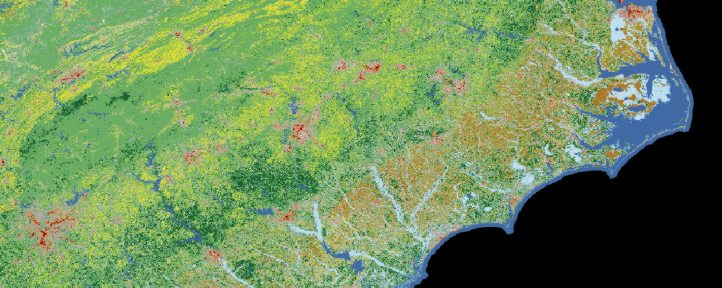
North Carolina landcover map
DRG from Terraserver server download
Set the resolution to 1.2 meters for DRGs. Their native resolution is
2.4 meters, so this is some pretty hefty oversampling:
g.region res=1.2 -ap
g.region save=drg-resolution

r.in.wms output=terraserver-drg mapserver="http://terraserver.microsoft.com/ogcmap6.ashx" \
         layers=DRG region=drg-resolution format=jpeg srs=EPSG:26910
REQUIRED PROGRAMS
r.in.wms requires the following programs to work:
- wget: An http download program, or
- curl: Alternate http download program
- bc: A calculator program
- sed, grep: Unix string processing and search programs
- gdalwarp: A reprojection tool,
needed only if data is projected into this location.
- xml2: An xml parser.
Enables more accurate listing of layers on the server.
SEE ALSO
r.tileset,
r.in.gdal,
r.patch,
r.colors,
r.composite
v.in.wfs
AUTHORS
Soeren Gebbert, Jachym Cepicky, and Cedric Shock
Last changed: $Date$