Horizon angles for test point (CCW from East)
The directions are given as azimuthal angles (in degrees), with the angle starting with 0 towards East and moving counterclockwise (North is 90, etc.). The calculation takes into account the actual projection, so the angles are corrected for direction distortions imposed by it. The directions are thus aligned to those of the geographic projection and not the coordinate system given by the rows and columns of the raster map. This correction implies that the resulting cardinal directions represent true orientation towards the East, North, West and South. The only exception of this feature is LOCATION with x,y coordinate system, where this correction is not applied.
The elev_in parameter is an input elevation raster map. If the buffer options are used (see below), this raster should extend over the area that accommodate the presently defined region plus defined buffer zones.
The horizon_step parameter gives the angle step (in degrees) between successive azimuthal directions for the calculation of the horizon. Thus, a value of 5 for the horizon_step will give a total of 360/5=72 directions (72 raster maps if used in the raster map mode).
The direction parameter gives the initial direction of the first output. This parameter acts as an direction angle offset. For example, if you want to get horizon angles for directions 45 and 225 degrees, the direction should be set to 45 and horizon_step to 180. If you only want one single direction, use this parameter to specify desired direction of horizon angle, and set the horizon_step size to 0 degrees. Otherwise all angles for a given starting direction with step of horizon_step are calculated.
The distance controls the sampling distance step size for the search for horizon along the line of sight. The default value is 1.0 meaning that the step size will be taken from the raster resolution. Setting the value below 1.0 might slightly improve results for directions apart from the cardinal ones, but increasing the processing load of the search algorithm.
The maxdistance value gives a maximum distance to move away from the origin along the line of sight in order to search for the horizon height. The smaller this value the faster the calculation but the higher the risk that you may miss a terrain feature that can contribute significantly to the horizon outline. Note that a viewshed can be calculated with r.viewshed.
The coordinate parameter takes a pair of easting-northing values in the current coordinate system and calculates the values of angular height of the horizon around this point. To achieve the consistency of the results, the point coordinate is aligned to the midpoint of the closest elevation raster cell.
If an analyzed point (or raster cell) lies close to the edge of the defined region, the horizon calculation may not be realistic, since it may not see some significant terrain features which could have contributed to the horizon, because these features are outside the region. There are to options how to set the size of the buffer that is used to increase the area of the horizon analysis. The bufferzone parameter allows you to specify the same size of buffer for all cardinal directions and the parameters e_buff, n_buff, s_buff, and w_buff allow you to specify a buffer size individually for each of the four directions. The buffer parameters influence only size of the read elevation map, while the analysis in the raster mode will be done only for the area specified by the current region definition.
The horizon parameter gives the prefix of the output horizon raster maps. The raster name of each horizon direction raster will be constructed as horizon_NNN , where NNN counts upwards from 0 to total number of directions. If you use r.horizon in the single point mode this option will be ignored.
The output parameter allows to save the resulting horizon angles in a comma separated ASCII file (single point mode only). If you use r.horizon in the raster map mode this option will be ignored.
At the moment the elevation and maximum distance must be measured in meters, even if you use geographical coordinates (longitude/latitude). If your projection is based on distance (easting and northing), these too must be in meters. The buffer parameters must be in the same units as the raster coordinates.
The calculation method is based on the method used in r.sun to calculate shadows. It starts at a very shallow angle and walks along the line of sight and asks at each step whether the line of sight "hits" the terrain. If so, the angle is increased to allow the line of sight to pass just above the terrain at that point. This is continued until the line of sight reaches a height that is higher than any point in the region or until it reaches the border of the region (see also the bufferzone,e_buff, n_buff, s_buff, and w_buff). The the number of lines of sight (azimuth directions) is determined from the direction and horizon_step parameters. The method takes into account the curvature of the Earth whereby remote features will seem to be lower than they actually are. It also accounts for the changes of angles towards cardinal directions caused by the projection (see above).
# determine horizon angle in 225 degree direction:
r.horizon elev_in=elevation direction=215 horizon_step=0 bufferzone=200 \
coordinate=638871.6,223384.4 maxdistance=5000
# determine horizon values starting at 90 deg (North), step size of 5 deg:
# save result in CSV file
r.horizon elev_in=elevation direction=90 horizon_step=5 bufferzone=200 \
coordinate=638871.6,223384.4 maxdistance=5000 output=horizon.csv
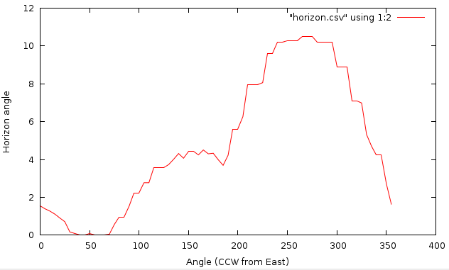
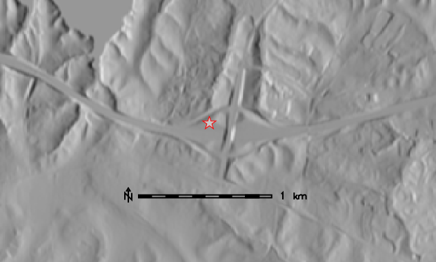
# test point near high way intersection
g.region n=223540 s=220820 w=634650 e=638780 res=10 -p
r.horizon elev_in=elevation direction=0 horizon_step=5 bufferzone=200 \
coordinate=636483.54,222176.25 maxdistance=5000 -d output=horizon.csv
Horizon angles for test point (CCW from East)
# we put a bufferzone of 10% of maxdistance around the study area
r.horizon elev_in=elevation horizon_step=30 bufferzone=200 horizon=horangle \
    maxdistance=5000
Hofierka J., 1997. Direct solar radiation modelling within an open GIS environment. Proceedings of JEC-GI'97 conference in Vienna, Austria, IOS Press Amsterdam, 575-584
Hofierka J., Huld T., Cebecauer T., Suri M., 2007. Open Source Solar Radiation Tools for Environmental and Renewable Energy Applications, International Symposium on Environmental Software Systems, Prague, 2007
Neteler M., Mitasova H., 2004. Open Source GIS: A GRASS GIS Approach, Springer, New York. ISBN: 1-4020-8064-6, 2nd Edition 2004 (reprinted 2005), 424 pages
Project PVGIS, European Commission, DG Joint Research Centre 2001-2007
Suri M., Hofierka J., 2004. A New GIS-based Solar Radiation Model and Its Application for Photovoltaic Assessments. Transactions in GIS, 8(2), 175-190
Thomas Huld, Joint Research Centre of
the European Commission, Ispra, Italy
Tomas Cebecauer, Joint Research Centre
of the European Commission, Ispra, Italy
Jaroslav Hofierka, GeoModel s.r.o.,
Bratislava, Slovakia
Marcel Suri, Joint Research Centre of the
European Commission, Ispra, Italy
© 2007, Thomas Huld, Tomas Cebecauer, Jaroslav Hofierka, Marcel Suri
Thomas.Huld@jrc.it Tomas.Cebecauer@jrc.it hofierka@geomodel.sk Marcel.Suri@jrc.itLast changed: $Date$