DESCRIPTION
r.li.edgedensity calculates:
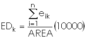
- the density of all edges of patch type k
 , or
, or
- the density of all edges in the sampling area if k is
not specified,
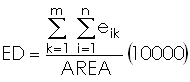
with:
- k: patch type
- m: number of patch types
- n: number of edge segments of patch type k
- eik :total edge length in
the landscape involving patch type k
- Area: total landscape area
The unit is meters per hectare.
NOTES
Do not use absolute path names for the output map/file.
If the "moving window" method was selected in g.gui.rlisetup, then the
output will be a raster map, otherwise an ASCII file will be generated in
the $HOME/.grass7/r.li/output/ folder.
If the input raster map contains only NULL values then r.li.edgedensity
consider to have 0 patches.
If area is 0 r.li.edgedensity returns NULL; this is only possible if input
raster is masked.
EXAMPLES
To calculate the edge density index on map my_map, using
my_conf configuration file (previously defined with
g.gui.rlisetup) and saving results in my_out, run:
r.li.edgedensity input=my_map conf=my_conf output=my_out
r.li.edgedensity input=my_map conf=my_conf output=my_out patch_type=34
Forest map (Spearfish sample dataset) example:
g.region rast=landcover.30m -p
r.mapcalc "forests = if(landcover.30m >= 41 && landcover.30m <= 43,1,null())"
r.li.edgedensity input=forests conf=movwindow7 out=forests_edgedens_mov7
r.univar forests_edgedens_mov7
SEE ALSO
r.li - package overview
g.gui.rlisetup
REFERENCES
McGarigal, K., and B. J. Marks. 1995. FRAGSTATS: spatial pattern
analysis program for quantifying landscape structure. USDA For. Serv.
Gen. Tech. Rep. PNW-351. (PDF)
AUTHORS
Serena Pallecchi student of Computer Science University of Pisa (Italy).
Commission from Faunalia Pontedera (PI), Italy (www.faunalia.it)
Markus Metz
Last changed: $Date$