DESCRIPTION
r.li.renyi calculates the "Renyi's diversity index" as:
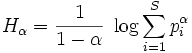
with:
- H: Renyi entropy
- alpha: order of the generalized entropy
- i: patch type
- S: number of different patch types
- pi: proportional abundance of
patch type i
NOTES
Do not use absolute path names for the output map/file.
If the "moving window" method was selected in g.gui.rlisetup, then the
output will be a raster map, otherwise an ASCII file will be generated in
the $HOME/.grass7/r.li/output/ folder.
If the input raster map contains only NULL values then r.li.renyi
returns NULL.
EXAMPLES
To calculate Renyi's diversity index on map my_map, using
my_conf configuration file (previously defined with
g.gui.rlisetup) and saving results in my_out, run:
r.li.renyi input=my_map conf=my_conf output=my_out alpha=0.6
Forest map (Spearfish sample dataset) example:
g.region rast=landcover.30m -p
r.mapcalc "forests = if(landcover.30m >= 41 && landcover.30m <= 43,1,null())"
r.li.renyi input=forests conf=movwindow7 out=forests_renyi_mov7_a06 alpha=0.6
r.univar forests_renyi_mov7_a06
SEE ALSO
r.li - package overview
g.gui.rlisetup
REFERENCES
McGarigal, K., and B. J. Marks. 1995. FRAGSTATS: spatial pattern
analysis program for quantifying landscape structure. USDA For. Serv.
Gen. Tech. Rep. PNW-351. (PDF)
AUTHORS
Luca Delucchi and Duccio Rocchini, Fondazione E. Mach (Italy), based on
the r.li.shannon code developed by Serena Pallecchi student of
Computer Science University of Pisa (Italy).
Last changed: $Date$