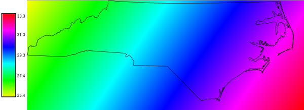
Sun angle map (in degree) of North Carolina for the 2010-10-11 at 14:00h solar time
Sun elevation, height, height angle, or solar altitude angle is the angle in degrees between the horizon and a line that points from the site towards the centre of the sun.
The sun azimuth angle is here defined as the azimuth angle in degrees of the sun from due north in a clockwise direction.
The time used here is defined such that 12:00 (high noon) is the time when the sun has reached its highest point in the sky at the current site, unless the -t flag is used in which case time is interpreted as Greenwich standard time.
If a sunhour output map is specified, the module calculates sunshine hours for the given day. This option requires both Greenwhich standard time and the use of the SOLPOS algorithm by NREL.
# set computational region to North Carolina state extent
g.region n=318500 s=-16000 w=124000 e=963000 res=500 -p
r.sunhours elevation=sun_elev year=2010 month=10 day=11 hour=14 minute=00

# visualize
d.mon wx0
d.rast sun_elev
d.vect nc_state type=boundary
d.legend sun_elev -s
g.region -p
r.sunhours sunhour=photoperiod_doy_001 year=2012 day=1
Last changed: $Date$