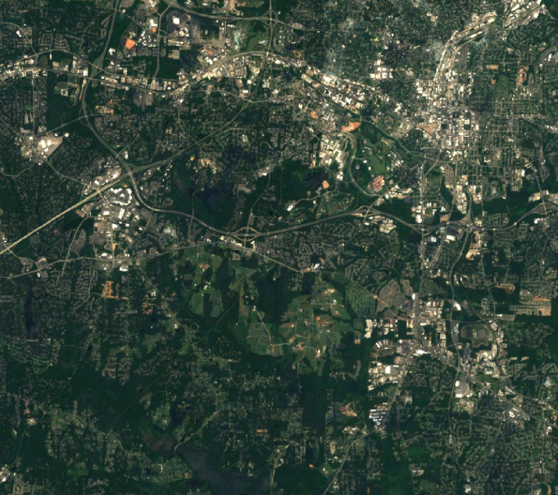
Figure: Raleigh (NC, USA) seen by Sentinel-2 (10m resolution; image courtesy: EOX)
If possible, the EPSG code of the current location should be used with the srs option to avoid unnecessary reprojection.
When using GDAL WMS driver (driver=WMS_GDAL), the GDAL library needs to be built with WMS support, see GDAL WMS manual page for details.
# Topographic WMS with OpenStreetMap by mundialis
r.in.wms -c url="http://ows.mundialis.de/services/service?"
r.in.wms -c url="http://ows.mundialis.de/services/service?" | grep Name

# Czech WMS
r.in.wms -c url="http://wms.cuzk.cz/wms.asp"
# OSM
g.region n=90 s=-90 w=-180 e=180 res=0:10:00 -p
r.in.wms url="http://watzmann-geog.urz.uni-heidelberg.de/cached/osm" layers=osm_auto:all output=osm format=png
r.info osm
# OSM Overlay WMS (can be used as an overlay for other maps)
r.in.wms url="http://ows.mundialis.de/services/service?" layer=OSM-Overlay-WMS output=osm_overlay format=png

# TOPO-OSM-WMS
r.in.wms url="http://ows.mundialis.de/services/service?" layer=TOPO-OSM-WMS output=topo_osm format=png
r.info topo_osm

# TOPO-WMS
r.in.wms url="http://ows.mundialis.de/services/service?" layer=TOPO-WMS output=topo format=png
r.info topo
More OSM WMS servers can be found online, e.g. on the OSM wiki in a OSM WMS Servers list and on the OSM-WMS-EUROPE page.
r.in.wms url="http://www2.demis.nl/WMS/wms.asp" layers=Countries,Borders,Coastline output=countries srs=4326 format=png
r.info countries
# North Carolina sample data
g.region raster=elevation -p
r.in.wms url="https://tiles.maps.eox.at/wms?" layers=s2cloudless output=sentinel2 format=png
r.info sentinel2
r.in.wms url="http://gpp3-wxs.ign.fr/yourAPIkey/geoportail/wmts" layers=ORTHOIMAGERY.ORTHOPHOTOS \
         output=orthophoto srs=3857 format=jpeg driver=WMTS_GRASS style=normal password="*" username="*"
r.info orthophoto
r.in.wms url="http://wms.cuzk.cz/wms.asp" layers=prehledka_kraju-linie srs=4326 output=kn format=png
r.in.wms url="http://geoportal.cuzk.cz/WMTS_ORTOFOTO/WMTService.aspx" layers=orto output=orthophoto \
         srs=3857 format=jpeg driver=WMTS_GRASS style=default
r.info orthophoto
# get WMS layer list
r.in.wms -c url="http://cidportal.jrc.ec.europa.eu/copernicus/services/ows/wms/public/core003?"
r.in.wms -c url="http://cidportal.jrc.ec.europa.eu/copernicus/services/ows/wms/public/core003?" | grep Name

# spatial subset of Europe
# enlarging maxcols and maxrows in order to minimize impact of copyright notice in map
g.region n=56 s=47 w=5 e=16 res=0:00:10 -pa
r.in.wms url="http://cidportal.jrc.ec.europa.eu/copernicus/services/ows/wms/public/core003?" \
         layer="OI.Mosaic.NaturalColor.Feathering" output="jrc_copernicus_core003_mosaik" \
         maxcols=3400 maxrows=3400
r.info jrc_copernicus_core003_mosaik
See also WMS support in wxGUI.
Last changed: $Date$