Location maps on the web
Posted by Barry Rowlingson on August 28, 2013
I had a play with leaflet and have embedded a map on the location pages, such as:
http://2013.foss4g.org/conf/programme/locations/auditorium/
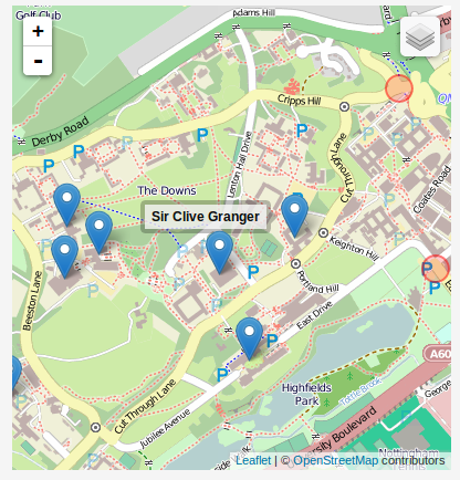
Note his map is not hyperlinked - locations are actually individual rooms and this is a map of buildings. Links to this map page come from presentation pages such as http://2013.foss4g.org/conf/programme/presentations/123/
Can ppl test this in safari, ie, iOS? Screenshot attached.
http://2013.foss4g.org/conf/programme/locations/auditorium/
Note his map is not hyperlinked - locations are actually individual rooms and this is a map of buildings. Links to this map page come from presentation pages such as http://2013.foss4g.org/conf/programme/presentations/123/
Can ppl test this in safari, ie, iOS? Screenshot attached.
Comments
Rollo Home on August 29, 2013:
It works on IE. and on the iphone...(but no turn-by-turn? Make it so ;-)
Barry Rowlingson on August 29, 2013:
Maybe our Nottingham-based committee members are off at conferences or motorbiking round the world so much they don't know their own campus :)
People will have the map on the programme (and on the lanyard too?) and there will be seven hundred people scurrying back and forth as well as our red-shirts so I'm not worried about anyone accidentally wandering off and falling in the pond. At least not while sober.
Mark Iliffe on August 29, 2013:
Barry Rowlingson on August 29, 2013:
Jeremy Morley on August 29, 2013:
Barry Rowlingson on August 29, 2013:
Jeremy Morley on August 29, 2013:
Mark Iliffe on August 29, 2013:
Jeremy Morley on August 29, 2013:
Steven Feldman on August 29, 2013:
Someone needs to work out what signs we want and get them printed off for laminating on the Monday and then get them fixed up (possibly a Monday volunteer task?)
Could someone who has less of an overload of taskks already pitch in and say I will do that (hint hint)
Mark Iliffe on August 29, 2013:
Rollo Home on August 30, 2013: