| FDO .NET API Reference | Feature Data Objects |
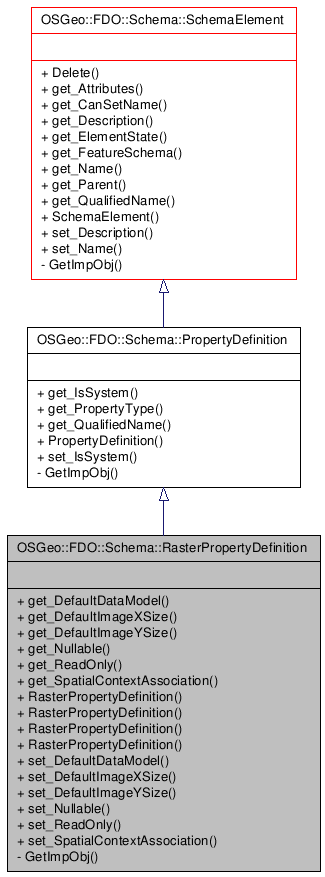
Inheritance diagram for OSGeo::FDO::Schema::RasterPropertyDefinition:

()
Definition at line 38 of file mgRasterPropertyDefinition.h.
Public Member Functions | |
| __property OSGeo::FDO::Raster::RasterDataModel * | get_DefaultDataModel () |
| Gets the default data model used by this raster property. | |
| __property System::Int32 | get_DefaultImageXSize () |
| Gets the default size of image file in the horizontal direction in pixels (number of columns). | |
| __property System::Int32 | get_DefaultImageYSize () |
| Gets the default size of an image file in the vertical direction in pixels (number of rows). | |
| __property System::Boolean | get_Nullable () |
| Returns a Boolean value that indicates if this property's value can be null. | |
| __property System::Boolean | get_ReadOnly () |
| Returns a Boolean value that indicates if this property is read-only. | |
| __property System::String * | get_SpatialContextAssociation () |
| Gets the Spatial Context name associated to this raster property. | |
| RasterPropertyDefinition (System::IntPtr unmanaged, System::Boolean autoDelete) | |
| Constructs a RasterPropertyDefinition object based on an unmanaged instance of the object. | |
| RasterPropertyDefinition (System::String *name, System::String *description, System::Boolean system) | |
| Constructs an instance of an RasterPropertyDefinition using the specified arguments. | |
| RasterPropertyDefinition (System::String *name, System::String *description) | |
| Constructs an instance of an RasterPropertyDefinition using the specified arguments. | |
| RasterPropertyDefinition () | |
| Constructs a default instance of an RasterPropertyDefinition. | |
| __property System::Void | set_DefaultDataModel (OSGeo::FDO::Raster::RasterDataModel *dataModel) |
| Sets the default data model used by this raster property. Allowed values are only those data models that are acceptable to the SupportsDataModel capability. | |
| __property System::Void | set_DefaultImageXSize (System::Int32 size) |
| Sets the default size of an image file in the horizontal direction in pixels (number of columns). | |
| __property System::Void | set_DefaultImageYSize (System::Int32 size) |
| Sets the default size of an image file in the vertical direction in pixels (number of rows). | |
| __property System::Void | set_Nullable (System::Boolean value) |
| Sets a Boolean value that indicates if this property's value can be null. | |
| __property System::Void | set_ReadOnly (System::Boolean value) |
| Sets a Boolean value that indicates if this property is read-only. | |
| __property System::Void | set_SpatialContextAssociation (System::String *spatialContextName) |
| Spatial Context Support. Sets a Spatial Context association for this raster property. | |
| Comments or suggestions? Send us feedback. |